
Coronavirus brings “The start of a very, very difficult era”, in which everyone should adapt hers/his needs.
In the aftermath of the World Health Organization’s designation of the novel coronavirus as a pandemic on March 11, various sectors across the globe emerged the reshaping of the these sectors.
The rapid spread of the pandemic across Asia, Europe, the Middle East, and the United States, countries have taken swift and decisive actions to mitigate the development of a full-blown pandemic.
Dr. Signer’s (Signer Lab) opinion editorial on the effectiveness of social distancing in mitigating the novel coronavirus pandemic is “imprinted” in the following graph.
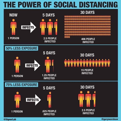 Social Exposure and Infections
The educational sector is one of the most important pillars of the society, that has been seriously affected by coronavirus. The pandemic has changed how students, professionals and groups are educated around the world and taking into consideration the “social distancing” e-learning / online education provides a critical tool to this pandemic phenomenon and helps the spreading mitigation.
Question:
Will coronavirus make online education go viral?
Answer:
Time will tell!
Space, Geospatial and Earth Observation domains have a huge number of followers, students, professionals and experts that needs education and training to improve their skills or widen their knowledge horizons. For this reason, GEO University provides an incredible and diverse Library of Courses for the aforementioned scientific domains.